Back to Districts 1-10
List of Districts & Boundaries
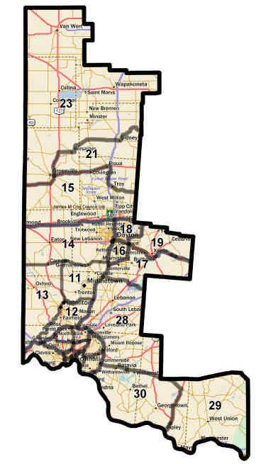
Click a section of the map to see district boundaries.
Click a district to see its boundaries
1-10 District Boundaries
Inside the I-275 loop in Ohio
Visit our website at districts1-10.org
11 District Boundaries
From the intersection of US 127 and the Great Miami River,
North on US 127 to SR 503,
North on SR 503 to SR 725,
East on SR 725 to I-75,
South on I-75 to SR 63,
West on SR 63 to SR 4,
Southwest on SR 4 to Liberty-Fairfield Rd.,
North on Liberty Fairfield Rd. to the Great Miami River,
Southwest on the Great Miami River to the start point.
12 District Boundaries
From the intersection of I-275 and the Great Miami River,
North on the Great Miami River to Liberty-Fairfield Rd.,
South on Liberty-Fairfield Rd. to SR 4,
North on SR 4 to SR 63,
East on SR 63 to I-75,
South on I-75 to I-275,
West on I-275 to the start point.
13 District Boundaries
From the intersection of I-275 and the Indiana-Ohio border,
North on the Indiana-Ohio border to SR 725,
East on SR 725 to SR 503, South on SR 503 to US 127,
South on US 127 to the Great Miami River,
South on the Great Miami River to I-275,
Southwest on I-275 to the start point.
14 District Boundaries
From the intersection of SR 725 and the Indiana-Ohio border,
North on the Indiana -Ohio border to I-70,
East on I-70 to I-75, South on I-75 to SR 725,
West on SR 725 to the start point.
15 District Boundaries
From the intersection of I-70 and the Indiana -Ohio border,
North on the Indiana-Ohio border to US 36,
East on US 36 to US 127,
North on US 127 to US 36,
East on US 36 to I-75,
South on I-75 to SR 41,
Southeast on SR 41 to the Miami-Clark county border,
South on the Miami-Clark county border to I-70,
West on I-70 to the start point.
16 District Boundaries
From the intersection of I-75 and I-675,
North on I-75 to US 35,
East on US 35 to I-675,
South on I-675 to the start point.
17 District Boundaries
From the intersection of I-75 and SR 73,
North on I-75 to I-675,
Northeast on I-675 to US 35,
East on US 35 to by-pass US 35,
East on by-pass US 35 to Hook Rd,
East on Hook Rd to Bickett Rd.,
North on Bickett Rd to US 35,
East on US 35 to the Greene-Fayette county border,
South on the Greene-Fayette county border to the Greene-Fayette-Clinton county border, West on the Greene-Clinton county border to the Greene-Clinton-Warren county border,
South on the Warren-Clinton county border to SR-73, West on SR 73 to the start point.
18 District Boundaries
From the intersection of I-75 and US 35,
East on US 35 to I-675,
North on I-675 to the Greene-Clark county border,
West on the Green-Clark county border to the Greene-Clark-Montgomery county border,
North on the Montgomery-Clark county border to I-70, West on I-70 to I-75,
South on I-75 to the start point.
21 District Boundaries
From the intersection of US 36 and US 127,
North on US 127 to SR 47,
East on SR 47 to the Shelby-Logan county border,
South on the Shelby-Logan/Shelby-Champaign/Miami-Champaign and Miami-Clark county border to SR 41,
West on SR 41 to I-75,
North on I-75 to US 36,
West on US 36 to the start point.
23 District Boundaries
From the intersection of US 36 and the Indiana-Ohio border,
North on the Indiana-Ohio border to the Van Wert-Paulding county border,
East on the Van Wert-Paulding county border to the Van Wert-Paulding-Putnam county border,
South on the Van Wert-Putnam/Van Wert-Allen county border to the Van Wert-Allen-Auglaize county border,
East on the Auglaize-Allen county border to the Auglaize-Allen-Hardin county border,
South on the Auglaize-Hardin county border to the Auglaize-Hardin-Logan county border,
West and South on the Auglaize-Logan/Shelby-Logan county border to SR 47,
West on SR 47 to US 127,
South on US 127 to US 36,
Southwest on US 36 to the start point.
28 District Boundaries
From the intersection of I-275 and I-75,
North on I-75 to SR 73, East on SR 73 to the Warren-Clinton county border,
South on the Warren-Clinton county border to the Warren-Clinton -Clermont county border,
East on the Clermont-Clinton county border to the Brown-Clinton county border,
East on the Brown-Highland county border,
South on the Brown-Highland county border to SR 32, West on SR 32 to I-275, North on I-275 to the start point.
29 District Boundaries
Western Brown & Southern Clermont Counties:
From the intersection of US 62 and the Ohio River,
North on US 62 to SR 32, Northwest on SR 32 to the Brown-Highland county border,
East on the Brown-Adams-Highland county border to the Adams-Pike county border,
Southeast on the Adams-Pike county border then
South on the Adams–Scioto county border to the Ohio River,
West on the Ohio River to the start point.
30 District Boundaries
From the intersection of Asbury Rd. and the Ohio River, North on Asbury Rd. to I-275, North on I-275 to SR 32, East on SR 32 to US 62, South on US 62 to the Ohio River, West on the Ohio River to the start point.